
YELLOWMAPS
YellowMaps Antoine AR topo map, 1:62500 Scale, 15 X 15 Minute, Historical, 1943, 19.8 x 16.5 in - Tyvek
168,82€
281,37€
Save 40% (112,55€)
-
 Order within 2 hours and 2 minutes to get between May 13 - May 19
 -
 Tracked Shipping on All Orders
-
 14-Day Returns
- Secure Payments
-
 24/7 Customer Support
Description
- Printed on Tyvek (synthetic)
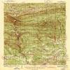
- USGS topographic map of Antoine, AR, at 1:62500 scale. Lighter material. Waterproof. Tear-resistant. Foldable. Very durable. Perfect for backpacking and the outdoors.
- Cities, towns, villages: Bethel,Shawmut,Dobyville,Love Creek,Lenox,Smyrna,Graysonia,Fendley,Pike Junction,Halfway,Alpine,Haretown,Boswell,Majors,Antoine,Clear Spring,Meeks Settlement,Nutts
- Mountains: Round Top Mountain,Ashworth Hill
- Valleys: Low elevation topographic features such as flatlands, river valleys, and canyons.
Printed on Tyvek
Shipping and Returns
- We offer tracked shipping on all orders. Tracking information will be shared as soon as the order is dispatched.
- Please check the delivery estimate before adding a product to the cart. This is displayed for every product on the website.
- Available shipping methods and charges will be displayed at the time of checkout, depending on your exact location.
- All customers are entitled to a return window of 14 days, starting from the date of delivery of the product(s).
- Customers are advised to read our return policy for details of the return process, eligibility, refunds as well as cancellations or exchanges.
- In case of any issues or concerns about Shipping or Returns, please contact us and we will be happy to help.
YellowMaps.
YellowMaps Antoine AR topo map, 1:62500 Scale, 15 X 15 Mi...
168,82€
281,37€
Save 40.0% (112,55€)