
YELLOWMAPS
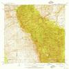
YellowMaps Galiuro MTS AZ topo map, 1:62500 Scale, 15 X 15 Minute, Historical, 1938, Updated 1956, 20.8 x 16.9 in - Tyvek
168,82€
281,37€
Save 40% (112,55€)
-
 Order within 3 hours and 15 minutes to get between May 13 - May 19
 -
 Tracked Shipping on All Orders
-
 14-Day Returns
- Secure Payments
-
 24/7 Customer Support
Description
- Printed on Tyvek (synthetic)
- USGS topographic map of Galiuro Mts, AZ, at 1:62500 scale. Lighter material. Waterproof. Tear-resistant. Foldable. Very durable. Perfect for backpacking and the outdoors.
- Cities, towns, villages: Sombrero Butte
- Mountains: China Peak,Maverick Mountain,Grassy Peak,Fourmile Peak,Rattlesnake Mesa,Kennedy Peak,Biscuit Peak,Sunset Peak,Cake Mountain,Rhodes Peak,Topout Peak,Bassett Peak,Kielberg Peak,Rockhouse Peak
- Valleys: Gardner Canyon,North Fork Douglas Canyon,Schoenholzer Canyon,Kielberg Canyon,Mailbox Canyon,North Field Canyon,South Negro Canyon,South Field Canyon,Cement Dam Canyon,Sunset Canyon,Ringtail Canyon
Printed on Tyvek
Shipping and Returns
- We offer tracked shipping on all orders. Tracking information will be shared as soon as the order is dispatched.
- Please check the delivery estimate before adding a product to the cart. This is displayed for every product on the website.
- Available shipping methods and charges will be displayed at the time of checkout, depending on your exact location.
- All customers are entitled to a return window of 14 days, starting from the date of delivery of the product(s).
- Customers are advised to read our return policy for details of the return process, eligibility, refunds as well as cancellations or exchanges.
- In case of any issues or concerns about Shipping or Returns, please contact us and we will be happy to help.
YellowMaps.
YellowMaps Galiuro MTS AZ topo map, 1:62500 Scale, 15 X 1...
168,82€
281,37€
Save 40.0% (112,55€)