
YELLOWMAPS
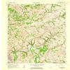
YellowMaps Greensburg KY topo map, 1:24000 Scale, 7.5 X 7.5 Minute, Historical, 1961, Updated 1962, 27.4 x 22.6 in - Polypropylene
156,60€
261,00€
Save 40% (104,40€)
-
 Order within 3 hours and 15 minutes to get between May 13 - May 19
 -
 Tracked Shipping on All Orders
-
 14-Day Returns
- Secure Payments
-
 24/7 Customer Support
Description
- Printed on Polypropylene (plastic)
- USGS topographic map of Greensburg, KY, at 1:24000 scale. Heavier material. Waterproof. Tear-resistant. Foldable. Perfect for the outdoors.
- Cities, towns, villages: Bengal,Burdick,Bluff Boom,Whitewood,Greensburg,Sweeneyville,Wrights,Black Gnat
- Islands: Snaps Island,White Island,Marcum Island,Hobson Island,Russell Island
- Parks and forests: National Parks, National Forests, etc. Please preview map image for specifics.
Shipping and Returns
- We offer tracked shipping on all orders. Tracking information will be shared as soon as the order is dispatched.
- Please check the delivery estimate before adding a product to the cart. This is displayed for every product on the website.
- Available shipping methods and charges will be displayed at the time of checkout, depending on your exact location.
- All customers are entitled to a return window of 14 days, starting from the date of delivery of the product(s).
- Customers are advised to read our return policy for details of the return process, eligibility, refunds as well as cancellations or exchanges.
- In case of any issues or concerns about Shipping or Returns, please contact us and we will be happy to help.
YellowMaps.
YellowMaps Greensburg KY topo map, 1:24000 Scale, 7.5 X 7...
156,60€
261,00€
Save 40.0% (104,40€)